Dunmore, Falcarragh, Co. Donegal € 75,000.00
Dunmore, Falcarragh, Co. Donegal
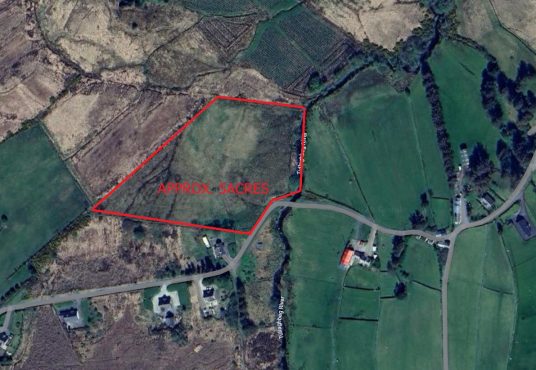
€ 75,000.00Land for sale as one lot Approx. 2.8acres On one side of the road there is 2.8 acres of arable land, a ruin and a agricultural shed in good condition.
Land for sale as one lot Approx. 2.8acres On one side of the road there is 2.8 acres of arable land, a ruin and a agricultural shed in good condition.
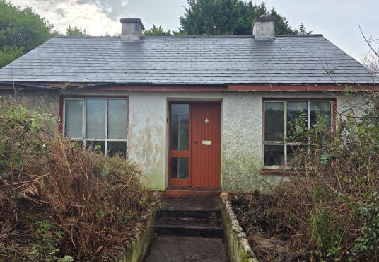
This unique property offers a fantastic opportunity for those with vision and a passion for renovation. Situated just 2.9km from the bustling town of Dungloe and 4.9km from the charming village of Loughanure, this derelict house sits on 0.53acres of land, offering ample space and privacy while still being easily accessible to local amenities. The…
Approx. 5 acres of land with planning permission for two houses. It is located approx. 6 kms from the town of Falcarragh with views of the Derryveagh Mountain range and the Tullaghobegley river running along the boundary of the site. For Planning details copy the link below https://www.eplanning.ie/DonegalCC/AppFileRefDetails/2350521/0 Co-Ordinates: 55.09856234734565, -8.101045042156384
Approx. 0.84acres site been sold subject to planning permission It is located approx. 1.4acres from the town of Falcarragh with views of the Ballyness and Hornhead in the distance and Derryveagh Mountain range. Co-Ordinates: 55.130844663102806, -8.116285500702709
Land approximately 0.26 hectares (0.64 acres) in total is subject to planning permission and is within walking distance to the town, schools, shops etc. Coordinates: 593721, 932452
This derelict property at Ardsbeg, near the coastal village of Gortahork in County Donegal, offers a unique opportunity for restoration or redevelopment in a scenic rural setting. Situated on a quiet site surrounded by natural countryside, the property enjoys a peaceful location while remaining within easy reach of local amenities and nearby beaches 0.69acres. The…
Site been sold subject to planning permission with stunning views located just 3km to Maghery and 6kms to the town of Dungloe. 1.2 acres. Co. ordinates are 54.92143953184857, -8.412056375244374 Part of Folio: DL31999F
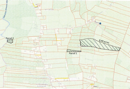
7.44 acres in total in three parcels of land. The first being the largest at 6.44 acres which divided by a laneway. The other two parcels of land have 1 acre between them. The lands are being sold as agricultural land or subject to planning permission. Co-ordinates: 55.10826011004599, -8.12855310419993
Plot of land been sold subject to planning permission Located on the R258 going towards Bunbeg. Excellent development opportunity Just a short distance from the schools, beaches, shops, pubs and restaurants in Gweedore Short drive to Carrickfinn airport Ideal to someone thinking of building a home Coordinates 55.05300311062318, -8.245639825510299
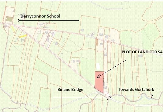
Approx.(1acre) plot of land Located short distance from Derryconnor school and a short drive to Magheroarty and the village of Gortahork. Price: POA Coordinates: 55.12670201605701, -8.174431793650017